

By Dr. Zaheer Malik
For many years, engineers in Pakistan have relied on imported CAD software. Licenses were expensive. Support was far away. Local standards and local realities often came second.
Now a different story is emerging. SPCAD, developed by Cadomation (Private) Limited in Lahore, is a homegrown plugin that works inside leading CAD platforms such as AutoCAD and BricsCAD. It does not try to replace these programs. Instead, it extends them and turns a general CAD environment into a spatially aware civil and GIS workspace.
SPCAD is already used in more than 50 countries. The message behind it is simple and confident: “Made in Pakistan, used globally.”
At first sight, SPCAD looks familiar. It lives inside the CAD screen that engineers already know. The ribbons, menus and commands sit next to standard CAD tools. There is no need to abandon existing habits or retrain whole teams from zero. Users stay in AutoCAD or BricsCAD. SPCAD adds the extra intelligence on top.
That extra layer is all about space and reality. SPCAD treats coordinates, terrain and ground position as core elements of every project. Lines and polylines are not just shapes on a black screen. They represent features on the earth, with real positions, elevations and relationships. This is why the product is presented as “The Spatial CAD.”
The plugin comes with more than 150 tools focused on civil engineering, surveying, GIS and town planning. The idea is that most steps in a spatial project can happen inside the same CAD session. A team can import survey points and breaklines, build a TIN surface, design a platform or a road, compute cut-and-fill volumes, and then prepare drawings and reports, all without leaving AutoCAD or BricsCAD. The need to jump between several separate applications is reduced. So are file conversions and the errors that often come with them.
SPCAD is also designed for teams that stretch across borders. It is available in eight languages: English, Spanish, Greek, Polish, Czech, Turkish, French and Portuguese. This means a designer in Pakistan, a checker in Europe and a contractor in South America can work with the same plugin in the same host CAD program, while each one uses the interface language that suits them. The data remains consistent. The tools behave the same. Collaboration becomes easier.
A major strength of SPCAD lies in the way it handles coordinate systems and projections. Many CAD users struggle when drawings must match survey grids, GIS layers or national coordinate systems. SPCAD places coordinate integrity at the center of the workflow. Users can work in local or global systems, transform data between them and keep survey, GIS and design layers aligned. For highways, canals, pipelines, city extensions and utility networks, this accuracy is not a luxury. It is essential.

Town planning and cadaster work are another focus area. Planning authorities and consultants can subdivide land, manage parcel areas and numbers, and match layouts with coordinate-based land records, all while staying inside their CAD environment. This helps them move smoothly from concept sketches to plans that support legal and administrative processes, without constantly switching to separate GIS software.
GIS and spatial professionals also find a bridge in SPCAD. They can work with geometry, attributes and coordinate systems inside a familiar CAD window, then pass spatially correct drawings back to engineers and contractors. The gap between CAD and GIS becomes smaller.
For Pakistan’s engineering and technology community, SPCAD represents more than a technical achievement. It shows that complex, domain-heavy software can be designed, built and supported locally, and still compete on a global stage. Creating a full spatial CAD plugin demands deep knowledge of geometry, projections, civil practice, GIS concepts and user experience. It takes years of refinement on real projects. The fact that SPCAD is now in use in more than 50 countries is a sign that this effort has found a market well beyond its home base.
With its spatial focus, multilingual interface and more than 150 specialized tools, SPCAD has moved beyond the idea of a simple add-on. It has become a spatial engine inside mainstream CAD platforms, connecting design, data and geography in one familiar workspace – from Pakistan to the rest of the world.
READ MORE

Always Robots Debuts in Malaysia to Drive AI-Powered Robotics Adoption
Always Robots has officially launched in Malaysia, marking its entry into the country’s growing robotics…

China’s Drug Trials Hit Record High as Biotech Growth Draws US Scrutiny
China registered a record 5,215 clinical drug trials in 2025, underscoring the country’s rapid rise…
China, Central Asia Partner on Satellite Network for Disaster Monitoring
China and several Central Asian countries have signed a technology cooperation agreement to develop a…

Rivers set free: Why countries are tearing down hundreds of dams
As the dams on the Hiitolanjoki in Finland came down, it began to change —…

Saudi Aramco Resumes Oil Loadings at Ras Tanura After Four-Month Suspension
Saudi Aramco resumed crude oil loadings at its Ras Tanura export terminal on Friday, ending…
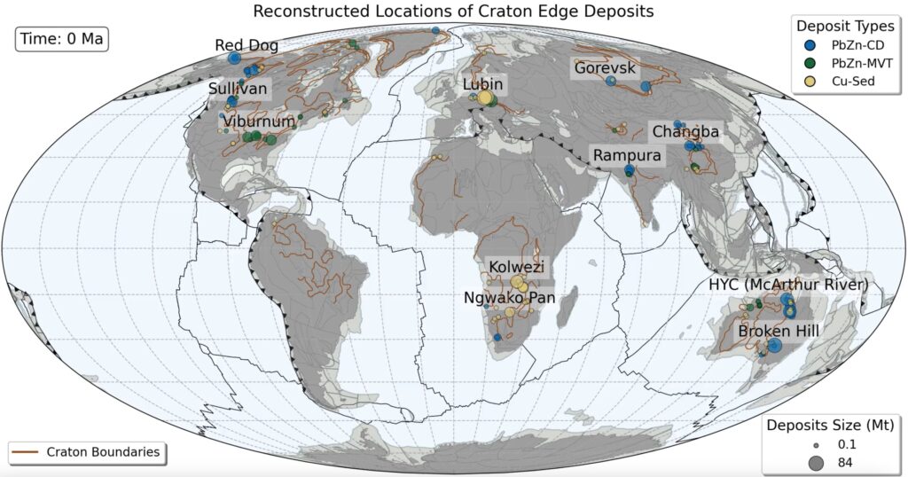
Study Links Ancient Subduction Zones to Major Copper, Zinc and Lead Deposits
Ancient subduction zones played a crucial role in the formation of some of the world’s…