
China and several Central Asian countries have signed a technology cooperation agreement to develop a satellite constellation aimed at improving disaster monitoring and environmental management through shared remote-sensing data.
The agreement was signed on Thursday during the ninth China-Eurasia Expo in Urumqi, the capital of China’s Xinjiang Uygur Autonomous Region, according to China’s state-run Xinhua News Agency.
Scientists from Kazakhstan, Uzbekistan and Tajikistan attended the signing ceremony, expressing confidence that the joint initiative would strengthen regional scientific cooperation and deliver mutual benefits.
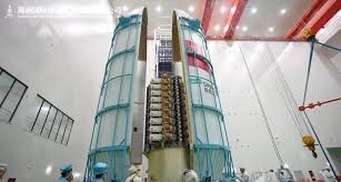
The project, named the Tianwu Constellation, will initially comprise five satellites designed to monitor geological and environmental risks across the region. The network will support efforts to detect earthquakes, landslides, glacial flood threats and agricultural pests.
Tong Qingxi, a remote-sensing expert at the Chinese Academy of Sciences, said Xinjiang shares similar geographical features and natural hazards with neighboring Central Asian countries, making the project well suited for regional collaboration.
Satellite data collected by the constellation will be processed at a computing centre in Xinjiang, where artificial intelligence models will be developed to enhance geological disaster forecasting, agricultural pest detection and glacial melt monitoring.
Akobir Mirzorakhimzoda, vice president of the National Academy of Sciences of Tajikistan, said advanced technologies such as satellite networking and AI would enable real-time environmental monitoring and analysis, providing a stronger scientific basis for decision-making.-ERMD
READ MORE

Engineering Review | July 1-15, 2026

China achieves first orbital-class sea-based rocket booster recovery
China on Friday successfully tested an experimental sea-based rocket recovery system, marking the country’s first…

Meta to Begin AI Chip Production in September, Targets Major Computing Expansion
Meta Platforms plans to begin production of its latest in-house artificial intelligence (AI) chip, code-named…
Pakistan, University of Illinois Chicago Explore Collaboration in Medical Research and Healthcare
Federal Minister for Planning, Development and Special Initiatives Ahsan Iqbal visited the University of Illinois…

UK Calls for Global AI Safeguards to Prevent Future Security Threats
Britain has called for urgent international action to establish safeguards for artificial intelligence (AI), warning…
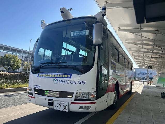
Japan to Begin Driverless Public Bus Trials in Fiscal 2027
Japan will begin testing fully autonomous buses for public transportation from fiscal year 2027 as…